El ave híbrida es el resultado de dos especies cuyos rangos de hábitat comenzaron a superponerse hace unas décadas, potencialmente debido al cambio climático, dijeron los investigadores.
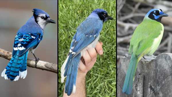
El nuevo pájaro descubierto (centro) es un híbrido de un arrendajo azul (izquierda) y un arrendajo verde (derecha), con características distintivas de ambas especies. (Crédito de la imagen: Brian Stokes (panel central), Travis Maher/Cornell Lab of Ornithology/Macaulay Library (izquierda) y Dan O’Brien/Cornell Lab of Ornithology/Macaulay Library (derecha).)Suscríbete a nuestro boletín
Por primera vez, los científicos han observado en la naturaleza a la descendencia híbrida de un arrendajo azul y un arrendajo verde durante un estudio cerca de San Antonio, Texas.
El ave híbrida es el producto de dos especies cuyos rangos de hábitat comenzaron a solaparse hace unas décadas, según un estudio publicado el 10 de septiembre en la revista Ecology and Evolution.
Los arrendajos azules (Cyanocitta cristata) y los arrendajos verdes (Cyanocorax yncas) son ambos tipos de córvidos, una familia de aves que también incluye a los cuervos y los grajos. A pesar de sus nombres similares, los arrendajos azules y los arrendajos verdes no están muy estrechamente emparentados. No comparten un género, y sus linajes se separaron hace unos 7 millones de años.
Los arrendajos verdes han vivido históricamente en zonas cálidas y tropicales de México, Centroamérica y el sur de Texas, mientras que los arrendajos azules se encuentran en gran parte del este de EE. UU., llegando hasta Houston hacia el oeste. Durante las últimas décadas, el aumento de las temperaturas ha permitido a los arrendajos verdes expandir su área de distribución más al norte, mientras que tanto el cambio climático como el desarrollo humano han empujado a los arrendajos azules más al oeste. Las dos especies ahora coexisten en una parte de Texas cerca de San Antonio.
Stokes, que estudia los arrendajos verdes en UT Austin, encontró al arrendajo híbrido a través de las redes sociales en 2023. Una observadora de aves de la zona de San Antonio había publicado una foto del inusual pájaro desde su patio trasero, y invitó a Stokes a su casa para observarlo más de cerca durante dos días.
“El primer día, intentamos atraparlo, pero se mostró muy poco cooperativo”, dijo Stokes. “Pero el segundo día, tuvimos suerte”.
Stokes logró atrapar al arrendajo en una red de niebla, una malla fina suspendida entre dos postes que es difícil de ver para las aves. El ave tenía plumaje azul pero marcas faciales similares a las de los arrendajos verdes, y podía emitir llamadas de ambas especies. Stokes tomó una muestra de sangre del ave y le colocó una anilla en la pata para ayudar a identificarla en el futuro, luego la liberó de nuevo en la naturaleza.
Un análisis genético de la muestra de sangre demostró que el ave era probablemente la descendencia de una hembra de arrendajo verde y un macho de arrendajo azul. El ave híbrida es el primer cruce conocido de estas dos especies en la naturaleza, pero en la década de 1970, los científicos criaron un arrendajo verde y un arrendajo azul en cautiverio. La apariencia del híbrido salvaje es similar a la del ave criada en cautiverio y taxidermizada, que ahora forma parte de las colecciones del Museo de Ciencia e Historia de Fort Worth.
A pesar de ser esta la primera vez que se informa del avistamiento de un híbrido de las dos especies, el arrendajo tenía al menos un año cuando Stokes lo marcó. Durante los dos años siguientes, nadie más informó haber visto al arrendajo, pero regresó al mismo patio trasero del área de San Antonio en junio de 2025.
Si hay otros arrendajos híbridos, podrían ser difíciles de detectar; fuera de San Antonio, pocas personas viven en la región donde se superponen las dos especies, por lo que las probabilidades de que alguien aviste un híbrido son bajas.
“La hibridación es probablemente mucho más común en el mundo natural de lo que los investigadores saben, porque hay una gran incapacidad para informar sobre estas cosas que suceden”, dijo Stokes.