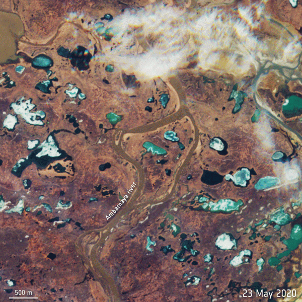
An image taken from space of an oil spill in the Arctic Circle. Oil is depicted in this animation (shown in red) traveling in the Ambarnaya River on May 31 and June 1.
Two European satellites have spotted a catastrophic oil spill in the Arctic Circle.
About 20,000 tons of diesel oil has leaked into a river in the Arctic Circle after a fuel tank at a power plant near the Siberian city of Norilsk collapsed last Friday (May 29). The Russian Investigative Committee has launched an investigation into the incident, as the plant reportedly waited for two days before informing Moscow authorities about the spill, according to the BBC.
As you can see in the animation above, the oil (depicted in red) traveled down the Ambarnaya River on May 31 and June 1. The river flows into Lake Pyasino, which feeds into the Pysaina River. Watching from space, the European Space Agency’s Copernicus Sentinel-2 mission has observed the spill, for which Russia has declared a state of emergency.
The spill has contaminated a swath of land that covers roughly 135 square miles (350 square kilometers), according to the BBC. It is believed that ground subsidence, or the sinking or settling of the ground, beneath storage tanks holding fuel at the plant is behind this spill. This incident comes during a time when unusually high temperatures are causing the Arctic permafrost to melt.
Copernicus Sentinel-2 is an ESA mission made up of two satellites circling Earth in a sun-synchronous orbit. The satellites monitor and take high-resolution images of Earth’s surface. They contribute important data to the European Union’s Copernicus program, which focuses on issues including climate change, land monitoring and emergency management.
Sourse: www.livescience.com


