
The Gulf of Mexico's “dead zone” – an area lacking oxygen – is smaller than previous measurements and projections, scientists working with the National Oceanic and Atmospheric Administration reported Thursday.
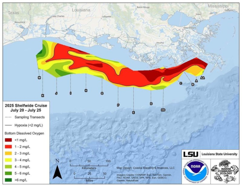
The Gulf's dead zone is 4,402 square miles, down 21 percent from estimates made in June and the 15th smallest on record.
That means about 2.8 million acres of bay habitat is now inaccessible to fish and bottom-dwelling species, down about 30 percent from last year, according to a NOAA news release.
Each summer, a dead zone forms off the coast of Texas and Louisiana when nutrient-rich freshwater enters the Gulf. The nutrients typically come from agricultural production, as they are needed for growth. These nutrients, which come from rivers, contribute to the formation of low-oxygen zones on the Gulf floor. Mobile fish and marine mammals can escape these areas. However, less mobile organisms can become trapped and die.
Scientists from Louisiana State University and the Louisiana Universities Marine Consortium conducted the annual dead zone survey from July 20 to 25 aboard the research vessel LUMCON Pelican.
This annual measurement is an important metric to assess the collective efforts of the Mississippi River/Gulf of America Hypoxia Task Force, which has set a long-term goal of reducing the five-year average extent of the dead zone to less than 1,900 square miles by 2035.
The Trump administration calls the Gulf “America's Gulf.”
“The significant reduction in the dead zone in America Bay this year is an encouraging sign for the future of this region,” said Laura Grimm, NOAA’s acting administrator, in a statement. “It highlights the dedication and productive work of NOAA-supported scientists and partners and is a testament to the effectiveness of collaborative efforts to support America’s fishermen, coastal communities, and vital marine ecosystems. We are proud of these accomplishments and continue to work on research and strategies that will ensure the health and vitality of our oceans for generations to come.”
In June, NOAA predicted an average dead zone size of 5,574 square miles, based largely on U.S. Geological Survey data on Mississippi River discharge and nutrient runoff. The measured size was within the uncertainty of NOAA's forecast.
While each NOAA-supported study provides a one-time view of the dead zone, the five-year average reflects how it changes over time. The current five-year average size of the dead zone is 4,755 square miles.
In June 2022, EPA established the Gulf Hypoxia Program to accelerate the Hypoxia Task Force’s nutrient reduction efforts and implement the Gulf Hypoxia Action Plan. As a result, Hypoxia Task Force member states are expanding their nutrient reduction strategies.
“America's Gulf is a national treasure that supports energy dominance, commercial fisheries, American industry and the recreational economy,” said Peggy Brown, acting assistant administrator of the Environmental Protection Agency's Office of Water Resources.
Sourse: www.upi.com