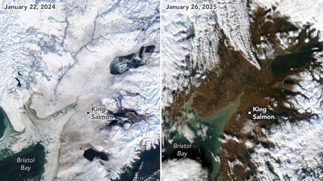

A NASA satellite image showing melting glaciers in Alaska. (Image credit: NASA Earth Observatory/Wanmei Liang)
New satellite images illustrate the rapid pace of global warming in Alaska, with last year's snow gone, leaving vast swaths of bare land.
Images from the Moderate Resolution Imaging Spectroradiometer (MODIS) instrument on NASA's Terra and Aqua satellites show the Bristol Bay region of southern Alaska. Anchorage, in the northeast, averaged 13 inches (33 centimeters) of snow in January from 1998 to 2025.
But this year, the station, like other areas of the state, reported almost no snow on the surface, leaving only large patches of land visible from space.
“Since December 2024, temperatures across the state have been 5 to 10 degrees Fahrenheit (3 to 6 degrees Celsius) above normal, according to NOAA, with some areas experiencing even greater anomalies,” NASA Earth Observatory wrote in a blog post accompanying the new images. “The warmer temperatures have caused remaining snow and ice to melt, and new precipitation to fall as rain.”
As climate change warms the Earth, Arctic regions like Alaska are experiencing dramatic warming rates, with temperatures rising four times faster than other parts of the world. The average temperature in Anchorage in January was 29.3 F (minus 1.5 C) — 13 F (7.2 C) above average and warmer than thirty other states.
The reasons for this phenomenon are twofold. First, unusual weather patterns in the North Pacific Ocean have caused a marine heat wave in North America this winter. This warming has been exacerbated in Alaska by a warm ridge of high pressure that has been hovering over the state.
Second, climate change is increasingly breaking down the region’s sea ice, which serves as a protective barrier that reflects the sun’s rays back into space. But this effect, known as albedo, is now working in reverse: Melting sea ice is revealing darker waters that absorb more sunlight.
This means that as the planet warms, Arctic regions are turning from refrigerators into radiators. This is reducing Alaska’s snowpack, which accumulates in the winter and melts in the spring. Climate models predict that by the middle of this century, significant reductions in snowpack will threaten the region’s glaciers and lead to stronger storms and more precipitation.
In late January, a dissipating high pressure front unleashed a blast of arctic winds that brought freezing temperatures across the state. However, local forecasts do not expect the condition to last long, with warmer-than-normal temperatures expected to return to the state by mid-February.

Ben TurnerNavigate Social LinksSenior Staff Writer
Ben Turner is a UK-based Live Science writer. He covers physics and astronomy, as well as other topics like technology and climate change. He studied particle physics at University College London before becoming a journalist. When he’s not writing, Ben enjoys reading, playing guitar, and losing embarrassingly at chess.
You must verify your public display name before commenting.
Please log out and log in again.
Sourse: www.livescience.com