MH370’s location may have been revealed in special “code messages” in leaked pictures, an aviation expert has told Express.co.uk.
Malaysia Airlines Flight 370 went missing on March 8, 2014, en route from Kuala Lumpur to Beijing with 239 people on board. The official investigation concluded that the Boeing 777 likely flew out over the Indian Ocean and crashed into the sea. However, no wreckage has ever been found there, despite extensive search attempts.
Trending
In the absence of a definitive answer to the mystery, there have been numerous other theories that have been proposed, including one that it actually ended up on an island in the South China Sea.
Aviation engineer Ismail Hammad told Express.co.uk believes that the pilot, Captain Zahari Ahmad Shah, may have been the one behind the attack and that it is possible he left clues in pictures taken before the attack.
He said: “If the pilot of the plane, Captain Zaharie Ahmad Shah, is the one who planned and carried out the hiding of the aircraft from radars and human eyes, as rumoured, I think he leaked to us a coded message symbolising the place of hiding in the first pictures that were leaked to the world of him in his home.”
This picture features the pilot, and three other people believed to be his wife and children

Mr Hammad added: “The drawing on the sofa is symbolising an archipelago.
“As if he wants to say that, whoever wants to find me and the plane, they should look for me on an island of some archipelago and not in the ocean.”
After MH370 disappeared from civilian air traffic control radar over the South China Sea on that fateful day, it took a U-turn and flew back towards Malaysia and then up the Malacca Strait towards the Andaman Islands.
This is known because the plane was still showing up on primary radar owned by the military.

However, after about an hour, the plane disappeared from military radar as well.
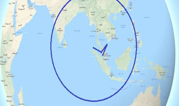
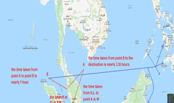
Mr Hammad believes, after MH370 disappeared from military radar near the Andaman Islands, it turned around again and flew back east.
He insisted that the supposed hijacker would have wanted to land the plane by around sunrise, and worked out a circle of possible destinations that the plane could have flown during that time, based on how fast it was flying.
The engineer concluded that it almost certainly flew back east and landed on an island in the South China Sea.
DON’T MISS
MH370 shock: Malaysian officials’ huge U-turn exposed [REVEALED]
MH17: How shooting down of plane was ‘calling card’ reference to MH370 [ANALYSIS]
MH370: Unusual turn that ‘proved’ plane hijack theory exposed [INSIGHT]

ne likely destination, he argued, was the Philippines, which consists of 7,641 islands, meaning there are plenty of islands to choose from, many of which are not largely populated, which would help for someone trying to disappear.
A few of the islands he listed as possible landing sites were Palawan, Mindanao, Badian, Negros, as well as the Sulu archipelago and its largest island Jolo.
He also suggested Borneo might be a good location, as there are three countries which claim areas of the Island, which helps with not attracting attention to oneself.
Indeed, whoever was in charge of MH370 the hours after it went missing seemed to be exploiting the loophole associated with border lines.
After taking a U-turn at waypoint IGARI and flying southwest and then northwest up the Malacca Strait, it flew along Flight Information Regions (FIRs) which meant the military in each country assumed the plane belonged to the other, and did not bother too much about it.
Hr Hammad told Express.co.uk: “If the hijacker decided to land and hide [in Borneo], that would have been a smart decision, because the follow of the northern part of the island belongs to the State of Malaysia itself.
“And the overlap of the border lines in this area is between three countries, which makes it a blind area for air traffic control, and these countries are Malaysia, Indonesia and The Philippines.
“Also the border lines between the many provinces of this island, especially the provinces of The North and The East Kalimantan, which are located on the eastern side of the island directly on the coast of the sea.
“This would have been an easy and incredible landing choice, especially because of the availability of the forest and the large number of swamps there.”
However, there are dozens of theories as to what happened to MH370, none of which are proven.
Sourse: www.express.co.uk


