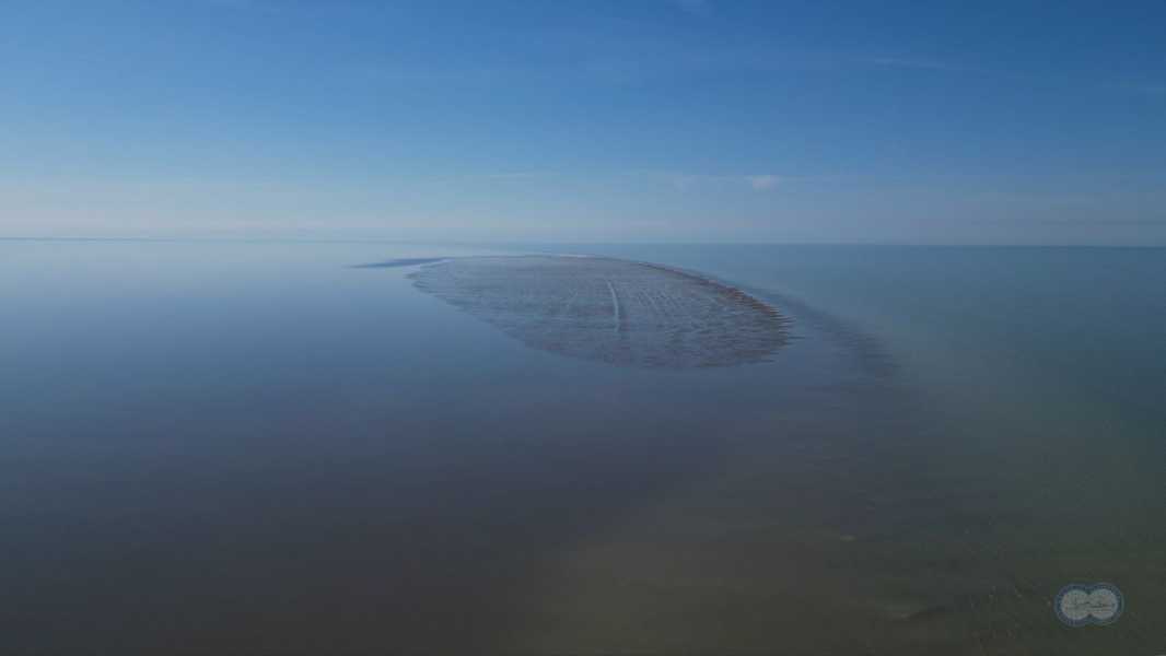

A new island has recently appeared in the Caspian Sea, but it does not yet have a name. (Photo: Yu. Shulgina, Video Studio of the Institute of Oceanology of the Russian Academy of Sciences)
A Russian scientific expedition has confirmed the appearance of a new island in the northern part of the Caspian Sea.
The island, which has not yet been named, is located 19 miles (30 kilometers) southwest of another island known as Maly Zhemchuzhny, according to a translation of the statement published by Russia's state-run TASS news agency. The island rises only slightly above the water's surface and was wet and mostly flat, but was covered with sand ridges during the expedition, the statement said.
As Stepan Podolyako, a senior researcher at the P. P. Shirshov Institute of Oceanology (IO RAS), who took part in the expedition, told Live Science, the new island was formed as a result of a drop in the water level in the Caspian Sea.
You may like
- 'Silent Chernobyl' changed the Earth's surface so much that the planet's mantle is still moving 80 years later
- Never-before-seen chain of volcanoes discovered near Cook Islands
- Four volcanoes at secret Soviet military base linked to climate-changing eruption 200 years ago
The Caspian Sea, located on the border between Europe and Asia, is the largest inland body of water on the planet when measured by its surface area, at 143,200 square miles (371,000 square kilometers).
“The emergence of new islands in the Caspian Sea is associated with cyclic processes of multi-year fluctuations in the level of [these] closed waters,” Podolyako noted in his report. “The Avashi Islands are elevations on the seabed that come to the surface during periods of lower sea levels.”
The Caspian Sea level dropped in the 1930s and 1970s, then recovered, and began to fall again around 2010, Podolyako explained.
Climate change may be responsible for the recent decline, as the Caspian Sea's water levels are partly dependent on evaporation rates, Podolyako added. There are also tectonic shifts under the sea that could explain the changes in water levels.
Scientists first spotted signs of a new island on satellite images in November 2024. According to TASS, a pile of sand and sediment had broken through to the water's surface and was beginning to dry out, but the claim that a new island had formed remained somewhat controversial.
Sourse: www.livescience.com