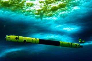
Icefin, an underwater robot, took a wild journey underneath a melting glacier in Antarctica.
An underwater robot named Icefin that has gone where no submersible has gone before — to the underbelly of Antarctica’s “Doomsday Glacier” — has uncovered unusually warm temperatures there.
The hunk of ice, officially known as the Thwaites Glacier, earned its ominous nickname because it is one of Antarctica’s fastest melting glaciers. Even so, scientists were surprised to learn that waters at the ground line, the region where the glacier meets the sea, are more than 3.6 degrees Fahrenheit (2 degrees Celsius) above the normal freezing temperature, according to news reports.
“Warm waters in this part of the world, as remote as they may seem, should serve as a warning to all of us about the potential dire changes to the planet brought about by climate change,” David Holland, a lead researcher on the expedition and director of the Environmental Fluid Dynamics Laboratory at New York University, told the Chicago Tribune.
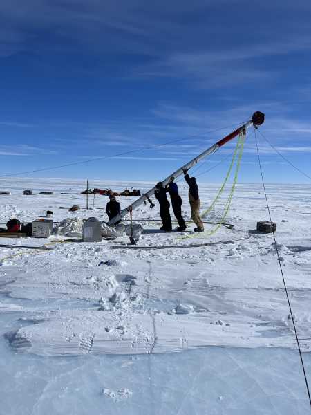
The journey to collect this data wasn’t easy. Scientists dropped the torpedo-shaped Icefin through a 2,300-foot-deep (700 meters) hole they had drilled through the glacier.
“We’re proud of Icefin, since it represents a new way of looking at glaciers and ice shelves,” Britney Schmidt, lead scientist for Icefin and an associate professor of Earth and Atmospheric Sciences at Georgia Tech, said in a statement. “For really the first time, we can drive miles under the ice to measure and map processes we can’t otherwise reach. We’ve taken the first close-up look at a grounding zone. It’s our ‘walking on the moon’ moment.” The grounding zone is the region where the underside of the glacier meets the seawater beneath it.
The team, dubbed MELT, or Melting at Thwaites grounding zone and its control on sea level, spent the last two months in minus 22 F (minus 30 C) weather at the glacier for the project. After descending the nearly half-mile hole through the glacier, Icefin swam more than a mile to the grounding zone. As it puttered along, Icefin took measurements and images so that scientists could later map the area, as well as understand the temperatures and the changing landscape there.
Image 1 of 4British Antarctic Survey researchers lower the hot water drill as they begin drilling through Thwaites Glacier so that Icefin would be able to reach the glacier’s grounding zone. Image 2 of 4Icefin’s team members, including those with the British Antarctic Survey, take part in Icefin’s deployment. Image 3 of 4A windstorm at Thwaites Glacier blows snow over the drill tower, Icefin launch frame and control tent. Image 4 of 4Icefin captured this image of sediments, rock and ice at the Thwaites Glacier grounding zone.
Thwaites Glacier, roughly the size of Florida, is melting at an increasingly fast rate. Its melt already accounts for about 4% of global sea rise, Georgia Tech reported. The amount of ice flowing out of Thwaites and the adjacent glaciers into the sea has doubled in the past 30 years, making it one of the fastest-changing areas of Antarctica.
Moreover, Thwaites is crucial to Antarctica because it slows the ice behind it from freely flowing into the ocean. The glacier’s ice shelf, or its permanent floating ice sheets, act like dirt in a clogged drain, impeding the glacier from flowing full force into the ocean, Stef Lhermitte, an assistant professor in the Department of Geoscience and Remote Sensing at Delft University of Technology in the Netherlands, previously told Live Science.
“We know that warmer ocean waters are eroding many of West Antarctica’s glaciers, but we’re particularly concerned about Thwaites,” Keith Nicholls, an oceanographer with the British Antarctic Survey and the United Kingdom lead on the MELT team, said in the Georgia Tech statement. “This new data will provide a new perspective of the processes taking place, so we can predict future change with more certainty.”
In addition to deploying Icefin, the researchers sent out ocean instruments and took sediment cores. The team even sent out a second Icefin vehicle to another location — the Ross Ice Shelf — in collaboration with Antarctica New Zealand.
The work was shown as a BBC World News special report yesterday (Jan. 28) as part of the 200th anniversary of Antarctica’s discovery. In the meantime, the researchers are still analyzing the data from Icefin and plan to publish their findings in March, according to The New York Times.
- Photo gallery: Antarctica’s Pine Island Glacier cracks
- In photos: Huge icebergs break off Antarctica
- Photographic proof of climate change: Time-lapse images of retreating glaciers
Sourse: www.livescience.com


