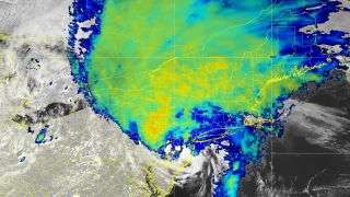
A satellite image of Isaias on Aug. 4 shows the storm moving north over the East Coast of the U.S. It made landfall in North Carolina on Aug. 3 as a Category 1 hurricane, but within hours had weakened to a tropical storm.
The Atlantic hurricane season roared off to a stormy and record-breaking start this year, with nine named storms forming by July 30. And it’s shaping up to be one of the more active seasons on record, according to experts with the National Oceanographic and Atmospheric Administration (NOAA).
Today (Aug. 6), NOAA researchers delivered an update to their hurricane season outlook, initially presented on May 21. The new outlook predicts an 85% chance of above normal activity, compared to the May prediction of a 60% chance.
NOAA models showed that the 2020 Atlantic hurricane season could bring up to 25 named storms — the highest number ever predicted by NOAA — with winds of at least 39 mph (63 km/h). Of those, nine to 11 storms could be hurricanes with winds of at least 74 mph (119 km/h) and as many as six storms could be major hurricanes with winds of 111 mph (179 km/h) or higher, according to NOAA’s lead hurricane season forecaster Gerry Bell.
On May 21, NOAA had reported that 2020 would bring 13 to 19 named storms, of which six to 10 could become hurricanes and up to six could become major hurricanes.
However, none of these predictions determine which hurricanes may make landfall, as a storm’s trajectory is shaped by weather conditions that are not predictable until about five to seven days in advance, Bell explained.
Several climate factors favor the formation of so many storms. One of these is ocean conditions trending toward La Niña, in which cool waters dominate in a belt across the equatorial Pacific Ocean, rather than conditions known as El Niño, when those waters are warmer. El Niño suppress the formation of hurricanes in the Atlantic Ocean; La Niña does not.
Other factors increasing the likelihood of more Atlantic hurricanes include warmer-than-average sea surface temperatures in the Caribbean Sea and in the tropical Atlantic Ocean; weaker tropical Atlantic trade winds; and an enhanced west African monsoon, NOAA says.
Beginning in 1995, these conditions have fueled more active hurricane seasons overall; since that year, 70% of hurricane seasons have seen above normal activity, with nine seasons qualifying as “extremely active,” Bell said. By comparison, in the decades leading up to 1995, only two hurricane seasons were through to be above normal, and none was considered to be extremely active.
The most active Atlantic hurricane season was 2005, with 28 named storms. While NOAA scientists aren’t predicting that level of activity for 2020, this year will nonetheless be one of the stronger seasons on record, according to Bell. What’s more, the conditions that brew active hurricane seasons aren’t going away anytime soon, he added.
“We’re not seeing an end to this era,” Bell said. “We’re 26 years into it, and we don’t know how long it’s going to last.”
A stormy start
Tropical Storm Arthur was the first named storm of the 2020 Atlantic hurricane season, and it formed on May 17 — weeks earlier than the season’s official start (Atlantic hurricane season runs from June 1 to Nov. 30). And by July 30 there had already been nine named storms, the most recorded since 1966, according to NOAA.
The season’s most recent hurricane, Isaias (ee-sah-EE-as), developed into a tropical storm on July 29. It drenched the Dominican Republic, the Bahamas and Puerto Rico, causing widespread landslides, storm surges and flooding before slamming into North Carolina on Aug. 3 as a Category 1 hurricane with sustained winds of 85 mph (137 km/h), according to The Weather Channel.
Isaias then traveled up the East Coast of the U.S. By the time the storm moved into Canada on Aug. 5 as a post-tropical cyclone, at least five people in the U.S. had been killed, neighborhoods in multiple states were flooded and approximately 2.8 million homes from North Carolina to Maine were left without electricity, CNN reported.
Growing intensityRelated Content
— Hurricanes from above: Images of nature’s biggest storms
— How strong can a hurricane get?
— Photos: Hurricane Dorian leaves devastation in its wake
Hurricanes’ destructive power is fueled in part by ocean heat, which poses troubling questions about the future of hurricane seasons in a warming world. Evidence already suggests that warmer oceans fuel increased storm intensity, Live Science previously reported. In a study published in May, scientists analyzed approximately 4,000 storms dating from 1979 to 2017; they found that storms in general are becoming more powerful, and that major tropical cyclones form more frequently.
In fact, the researchers discovered that in that 39-year span, the odds of major hurricane formation have risen by about 15%, and most of that increase happened between 1998 and 2017.
According to the NHC’s list of Atlantic tropical storm names, the next contenders after Isaias are Josephine, Kyle and Laura. There are 21 names on the hurricane season list — from Arthur to Wilfred, in 2020 — and 2019 saw 18 named storms by the time the season drew to a close, NOAA reported last year.
Sourse: www.livescience.com


